


The blizzard of 2015 blasted the region with wind-whipped snow that piled nearly 3-feet high in some places.
As of 1 p.m. Monday, Boston set a new record for snowiest seven-day period in the city's history with 34.2 inches.
Get Started for FREE
Sign up with Facebook Sign up with X
I don't have a Facebook or a X account


 Your new post is loading...
 Your new post is loading...
Your new post is loading...
The blizzard of 2015 blasted the region with wind-whipped snow that piled nearly 3-feet high in some places. As of 1 p.m. Monday, Boston set a new record for snowiest seven-day period in the city's history with 34.2 inches.
Seth Dixon's insight:
Weather is one of the most tangible ways in which the physical environment impacts society. We depend on sunlight and rainfall, we adapt our behaviors to harsh conditions and we are constantly modifying the our environments by heating and cooling our buildings. This Henry David Thoreau quote reminds us to acknowledge the powerful influence of the environment and to recognize that technological fixes have their limitations. “Live in each season as it passes...and resign yourself to the influence of the earth.” --Henry David Thoreau Question to Ponder: In what ways does the weather shape and influence culture and spatial patterns in your region? How can we make our communities more handicap accessible during winter storms and other extreme conditions? Tags: environment, weather and climate, environment depend, environment adapt, environment modify, disasters. 

The news from the Philippines, where it's feared that last week’s powerful Typhoon Haiyan killed more than 10,000 people, isn’t getting better as hundreds of thousands of people struggle to survive and authorities struggle to get help to them. "Its absolute bedlam right now," says Richard Gordon, head of the Philippine Red Cross. “There's an awful lot of casualties, a lot of people dead all over the place, a lot of destruction.” According to the BBC, a huge international relief effort is underway, but rescue workers have struggled to reach some towns and villages cut off since the storm.

Al Picozzi's curator insight,
November 13, 2013 10:00 PM
Just the remoteness of the area is going to hinder the relief efforts. Even though the supplies are getting through it is getting through to the areas that need it the most is the problem. When the infrastructure is not that good to begin with, the damage done by this kind of disaster is multiplied. Look at New Orleans when Katrina hit. It still took days for relief and just water to get where it was needed. Imagine what that would have been like if the infrastructure was like like that of the Philippines. The country is overwhelmed by this disaster and needs the help. Its getting it but the problem still exists of how to distrbute it now that it is there. Makes you wonder if Subic Bay was still open as a US military base if it would have made it easier. Sometimes having a military base is not a bad thing. 
Rebecca Farrea's curator insight,
November 14, 2013 8:50 AM
Even though the death toll resulting from Typhoon Haiyan is around 1,000, it is expected to reach 10,000. International aid will hopefully help cities such as Tacloban City recover from this storm. 
Tracy Galvin's curator insight,
May 3, 2014 7:05 PM
With so many of the citizens living on the coast, a large typhoon like this completely destroys most of the country. When this much devastation happens all at one time it takes a very long time to recover.
This is a link from the Rhode Island Geography Education Alliance now on Twitter.

Nearly a week after Hurricane Irene drenched New England with rainfall in late August 2011, the Connecticut River was spewing muddy sediment into Long Island Sound and wrecking the region's farmland just before harvest.
The effects of the flooding in Vermont and New Hampshire graphically manifested on the downstream parts of the watershed. Good image for showing fluvial deposition and stream load.
|
Volunteers across the world are building the digital infrastructure for the organization's Typhoon Haiyan relief efforts Want to see geographic knowledge and geospatial skills in action? Crowd-sourced mapping is increasingly an important resource during an emergency. Poorer places are often not as well mapped out by the commercial cartographic organizations and these are oftentimes the places that are hardest hit by natural disasters. Relief agencies depend on mapping platforms to handle the logistics of administering aid and assessing the extent of the damage and rely on these crowd-sourced data sets. Can you join in and help?

Tony Aguilar's curator insight,
November 13, 2013 3:32 PM
online maps are being used to help locate the best way possible to help transport food and resources to those most in need. They van locate bridges and the world is pulling together with tehcnolgy and accurate maps to help the American red Cross maximize in time and manpower. It seems that after Hurricane Katrina and the Earthquakes in Haiti and Japan, We have been improving our strategies for how to best help people around the globe come together put our time energy and resources together to best help people whose lives have been devasted and crushed by the forces of mother nature.
Tracy Galvin's curator insight,
May 3, 2014 7:14 PM
Having a map of the current landscape, after the typhoon will speed up relief and rescue efforts by showing areas to land and set up help stations. The digital world is immediate now and this will change how organizations such as the Red Cross provide relief to suffering people.
"Learn how advances in geospatial technology and analytical methods have changed how we do everything, and discover how to make maps and analyze geographic patterns using the latest tools."

's comment November 6, 2013 9:41 PM
GIS is redefining mapping skills. In 21st Century education, it is crucial that we communicate GIS literacy in our geography curriculums and classrooms. As a geography teacher it is, therefore, also crucial that I have a thorough and sound knowledge of this field. This course could strongly assist such an understanding as professional development throughout my teaching career.
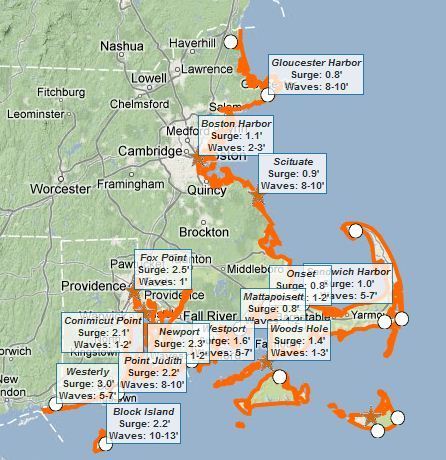
This interactive map of coastal Massachusetts and Rhode Island shows some basic flooding data including: 1) where are the flood warnings (essential the entire coastline), 2) how high the storm surge is, and 3) how high the waves are. Tags: Rhode Island, water, disasters, geospatial.
|


Not to mention the snow drifts up to 10-12 feet!
Human/Environment Interaction is one of the principles of Geography. Weather is about the simplest form of Human/Environment action there is. Weather and climate effect humans in may ways. Both of these have direct impact on agriculture and because of this the rise of civilization in the fertile crescent. But weather doesn't just dictate the rise of agriculture and civilization it effects us everyday. The picture shows Boston covered in record breaking snow fall. This altered many peoples schedules, closed businesses, canceled sporting events, forced people to spend time shoveling snow, gave work for snow plowers, and all in all effected the entirety of Boston.